A group of elementary-aged students gather outside of Oldham County Public Library in La Grange, Kentucky, United States to look at clouds in the sky. “If anyone asks what you are doing, tell them, ‘I am a citizen scientist and I am helping NASA,’” Children’s Programming Librarian, Cheri Grinnell, tells the kids. Grinnell supports an afterschool program called Leopard Spot where she engages K-5 students in collecting environmental data with the GLOBE (Global Learning & Observations to Benefit the Environment) Program.
“One little boy really got excited about that, and I heard him tell his mom he was working for NASA as they were leaving,” says Grinnell. That idea is reinforced when the program receives an email from NASA with satellite data that align with the cloud data the students submitted. “I forwarded the NASA satellite response to the after-school coordinator, and she read it to them. That really excited them because it was evidence this is the real deal.”
This experience is one the GLOBE Observer Team (part of the NASA Science Activation program’s NASA Earth Science Education Collaborative, NESEC) hears often: GLOBE volunteers of all ages love getting an email from NASA that compares satellite data with their cloud observations. “Feedback from NASA is huge. It’s the hook,” says Tina Rogerson, the programmer at NASA Langley Research Center who manages the satellite comparison emails. “It ties NASA science into what they saw when they did the observation.”
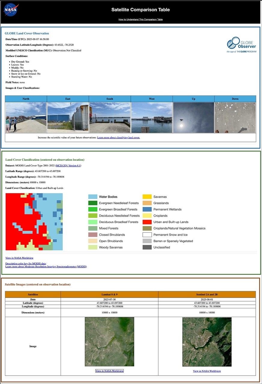
Now, volunteers will have more opportunities to receive a satellite comparison email from NASA. GLOBE recently announced that, in addition to sending emails about satellite data that align with the cloud observations made by learners, they will now also be sending emails that compare the GLOBE Observer Land Cover observations made by learners with satellite data. The new satellite comparison for land cover builds on the system used to create cloud comparisons at NASA Langley Research Center.
When a volunteer receives the email, they will see a link for each observation they have submitted. The link will open a website with a satellite comparison table. Their observation is at the top, followed by a satellite-based assessment of the land cover at that location. The last row of the table shows the most recent Landsat and Sentinel-2 satellite images of the observation site. Rogerson pulls GLOBE land cover data from the public GLOBE database to generate and send the comparison tables on a weekly basis. While users may opt out of receiving these emails, most participants will be excited to review their data from the space perspective.
These new collocated land cover observations are expected to raise greater awareness of how NASA and its interagency partners observe our changing home planet from space in order to inform societal needs. They will help every GLOBE volunteer see how their observations of the land fit in with the wider space-based view and how they are participating in the process of science. Based on the response to cloud satellite emails, seeing that bigger, impactful perspective via the satellite comparison email is motivating. The hope is to encourage volunteers to continue being NASA citizen scientists, collecting Earth system observations for GLOBE’s long-term environmental record.
“I’m excited that land cover is finally becoming part of the operational satellite comparison system,” says Rogerson. This means that GLOBE volunteers will routinely receive satellite data for both land cover and clouds. “We are bringing real science right into your world.”
NESEC, led by the Institute for Global Environmental Strategies (IGES) and supported by NASA under cooperative agreement award number NNX16AE28A, is part of NASA’s Science Activation Portfolio. Learn more about how Science Activation connects NASA science experts, real content, and experiences with community leaders to do science in ways that activate minds and promote deeper understanding of our world and beyond: https://science.nasa.gov/learn/about-science-activation/.
Source link


